Saturday, September 29, 2018

Alaska Trip - Haines

 July 19 – 21, 2018
Kluane Lake
From Valdez, we drove north on highway 1 to Tok, stopping on the way at Wrangell-Mt. Elias National Park Visitor Center. Next door, the displays in the Ahatna Cultural Center centered on the important role that salmon played in the lives of the local Athabaskan tribes throughout their history.
Our stop in Tok for gas and groceries was our second time there, so in a way it completed our irregular “circle” round Alaska.
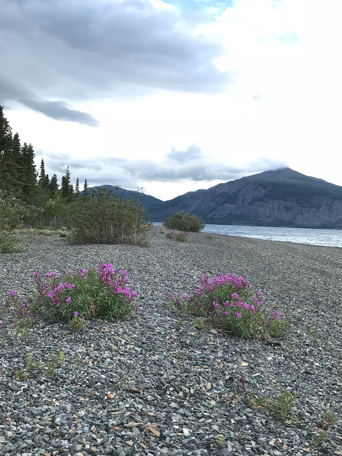
From Tok, the road (#2) heads southeast to Haines Junction, leaving Alaska on the way for the Yukon Territory. A highlight on that stretch was Kluane Lake (in the Yukon,) a very large glacier-fed lake that is now rapidly receding (20 feet in 2 years) due to a shrinking glacier changing course and creating zero run-off into the lake. Near the lake we stopped at Thachal Dhal Visitor Center (Sheep Mountain) The slopes of very large hills behind the center are the winter grazing area for hundreds of Dal sheep that live in the Kluane National Park.
Between Haines Junction and Haines, we stopped along the side of the road to watch 2 juvenile golden eagles soaring above us with their white spotted wings and white on their tails. That was a first!


Chilkot Lake 
After driving back into Alaska, just outside of Haines on the Chilkat River, we stopped at the Bald Eagle Preserve.  Many eagles nest in the area and are especially visible in late fall after their young have fledged and they are gathering before migrating. I spotted four eagles perched in trees above the river, and then 3 in another area, and then 2 in a different                                                                                    location. They’re around.


We spent 2 nights in Haines, AK. We decided to try to get a spot on the car ferry that runs from Haines to Skagway, 15 miles across the narrow inlet of the upper Lynn Canal. From Skagway we could drive north on the Klondike highway to Carcross and the Alaska Highway instead of driving back out of Haines on the same road we drove to get there. We found out we could get a stand-by ticket for a crossing in two days, so we decided to take our chances on that.
We camped our first night in Haines at Chilkat Lake State Rec Site. The road into the Campground runs along the beautifully aqua Chilkat River where lots of fishermen in chest high waders stood in the water casting their lines.
The next day we moved to Oceanside RV Park, a private RV parking lot right on Portage Cove on Haines’ waterfront. The weather cleared, and the sun came out, revealing the mountains that enclosed the very calm cove. We had a perfect afternoon for sitting and watching the pair of belted kingfishers who hung out near us and the bald eagles that frequented that side of the cove. The next day we toured the town, drove the water front roads that extend out from the town, bought salmon at a fish processing plant and, following Nina’s ever friendly lead, got to know our camping neighbors from Germany. In fact, we rode the ferry with them to Skagway on Friday and camped with them that night at Conrad Yukon Government Campground near Carcross.
Main Street, Haines
And then it was time to head east into British Columbia.
Eagle on a rock near Haines

Eagle on a rock near campsite
Fort William H Seward in Haines 
Sheldon Museum


Portage Cove, Haines


Driving onto the ferry for Skagway

Our new German friends

Good-bye to Haines

Friday, September 28, 2018

Alaska Trip - Valdez


 Our time spent in Anchorage consisted of camping on two different occasions at Eagle River Campground which is part of Chugach State Park. The town of Eagle River is a suburb northeast of Anchorage and it’s a handy place to stop going and coming from the Kenai Peninsula. Our second night there was after we’d toured Whittier and Portage Glacier. My sighting of Mama Moose and her baby in the campground is why I’m including a mention of it.
Lake Louise
The next morning, we visited the Ulu Factory in downtown Anchorage. The Ulu is a curved knife originally designed and made from stone by the Athabaskan natives. Now, of course, the blade is made of steel and it is mass produced. From the factory, we walked to Ship Creek and watched several fishermen casting their lines. We drove the downtown harbor residential area full of interesting upscale modern homes and condos. And then we made our way to 5th Avenue which is Highway #1 and away we went northeast out of town toward Palmer and the Glenn Highway.
It’s 187 miles on the Glenn Highway to Glenallen where we wanted to head south to Valdez. It’s a beautiful drive with the Chugach Mountains to the south and the Talkeetna Mountains off to the north. And where there wasn’t construction going on, the road was good pavement. Not so the 19- mile road to Lake Louise north of the Glenn Highway, 29 miles shy of Glenallen, where we decided to turn off and camp for the night. It was 19 miles of frost-heaved, patched, roller coaster road lined with stunted black and white spruce trees. Lake Louise is a beautiful setting, however, and we enjoyed our night there, despite the mosquitoes.
Valdez
Located on a fjord where the 5,000-foot-tall Chugach Mountains rise from Prince William Sound, the town of Valdez (population: 4011) sits at the base of Keystone Canyon, a 3-mile long gorge through nearly perpendicular slate walls sporting the Horsetail Falls and Bridal Veil Falls.
We drove into town on a Sunday and had a leisurely look around since most of the shops on the boardwalk near the marina were closed and there was little traffic. In fact, we just parked by the marina and ate our lunch in the Siesta while watching people walking to and from the fish processing facility not far away, and as we gazed at the variety of boats moored in the marina. Across the street was an incredible stand of blooming lupines!
Dayville Rd camping
View on Dayville Rd
We camped that night on Dayville Rd. which is across the Sound from the town of Valdez. This public road has wide paved turnouts overlooking the Sound for RV parking and fishing from the bank a few steps away. The Michigan couple parked next to us spend several days every summer there fishing and canning the fish they catch before moving on to other fishing areas in southern Alaska. A short distance up the road is the Solomon Gulch Fish Hatchery. Sea lions hang out there to catch and devour pink salmon flopping about at the fish weir. Bears are prevalent in the area, too, so we read. And Monday morning a small one rambled out of the shrubs by the Siesta just after Michael left to walk down to the bathroom. The bear was out on the road by the time another camper alerted Michael to it.
Part of the fascinating beauty of the Valdez area is the dramatic climate changes, from sea level fjord surrounded by mountains and glaciers up through Keystone Canyon, continuing 25 miles north of Valdez to Thompson Pass at 2,805 feet. That’s high enough at this northern latitude to be above tree line and home to several different blooming sedums and other tundra plants. And 4 miles beyond the pass is Worthington Glacier State Recreation Site, a National Natural Landmark.

Bridal Veil Falls

Keystone Canyon

Tundra at Thompson Pass

Tundra


Tundra

Worthington Glacier


Alaska Trip - Whittier & Portage Glacier

 July 13, 2018
Driving north 20 miles from Seward, we stopped in Moose Pass for breakfast at Trail Lake Lodge.  Across the road from the Lodge is an old water wheel with the sign, “Moose Pass is a peaceful little town.  If you have an axe to grind DO IT HERE.”  There’s a working lathe run by the waterwheel for your grinding needs.
downtown Whittier
It was a gray, cold, blustery day with intermittent sprinkles.  We were headed north to Anchorage and from there, east to begin our circuitous way back to Canada and then Michigan. Twenty miles north of our breakfast stop, we turned off Seward Highway for Portage Glacier and Whittier. We thought we’d visit the glacier first, and, if we felt we had time, we’d drive the 10 miles more to Whittier. However, with a little confusion over road construction signs, we took a left fork instead of a right, and there we were in the line going through the tunnel to Whittier.  I guess that inked our decision.
Whittier condo building
Downtown Whittier
The tunnel one must drive through to get to Whittier was originally a train tunnel. The Anton Anderson Memorial Tunnel was built in 1941-43 as part of the effort to safeguard the flow of military supplies from the port of Whittier. Until 2000, the only way to get to Whittier was by train. Trains still run through the tunnel on a regular basis, but because of upgrades to the tunnel’s road surface, cars can use it, too, one direction at a time, straddling the tracks, when no trains are scheduled. Vehicles line up in the staging areas and wait for the computerized system to give the go-ahead to each direction of traffic. It takes about 6 minutes to drive through the tunnel at 25 m.p.h.
Whittier, set on the edge of Prince William Sound, closed in by mountains, is a small village of a couple hundred people, most of whom live in one of two condo buildings.  There are no houses. There is a busy harbor on the Sound for cruise ships, the Alaska State Ferry System ferries, fishing boats, charter boats, and boats off-loading to the train. And there are parking lots for all the cars belonging to people on the ferry and other boats.  There are a few businesses crammed along the waterfront – a restaurant, a small hotel and gift shops and there are a few fish processing buildings. It was very much a place for coming and going, not staying.
So, we took a few photos, got fuel for the Siesta, let Nina run around on a grassy area and then we got back in line to go through the tunnel the other way.
Glacier ice
This time we stopped at the Visitor Center near Portage Glacier.  The US Forest Service operates the Begich, Boggs Visitor Center. Portage Lake sits behind the building.  Across the lake is Portage Glacier which, a woman sitting at the viewing window told me, reached down from the mountain to the edge of the lake 20 years ago when she had last visited.  Now the glacier only stretches a short way down the mountain cut. A chunk of glacier ice was floating in the lake. 


Visitor Center


Nearby Byron Glacier